
April 25, 2026
2026 VQ Event Day Info
Starting Area Map
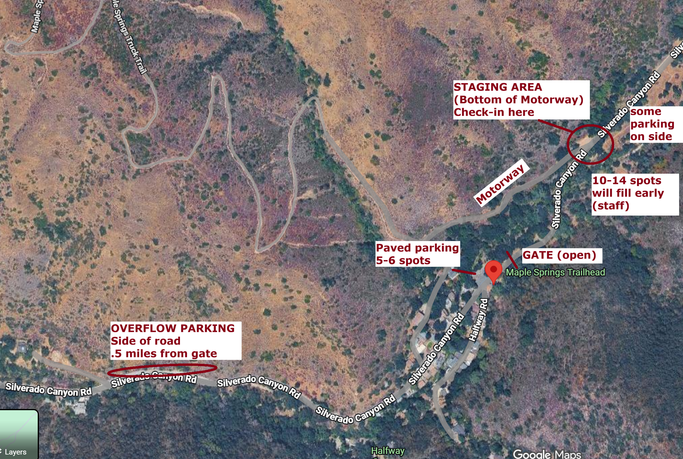
Staging Area
Rides start and end at the very bottom of Motorway.
This is .1 mile BEYOND the open Forest Service gate in a DIRT parking area.
Start, end and check-in here
See map pin:
https://maps.app.goo.gl/fQ89Qo4aFYCkKfdE6
Parking
Parking will be limited in the staging area (dirt lot).
If full, look up canyon or turn around and go back to overflow parking .5 mile back down the canyon.
See overflow parking map pin:
https://maps.app.goo.gl/y3coxiV7QQdvjiHn7
Morning Check-In
Arrive early to find parking, get ready.
5:15AM check-in opens at STAGING AREA
You are required to use a bell. This will be verified.
Give us your drop bag (food/supplies). This will be brought to the aid station.
You will receive a number plate.
5:40AM line up at STAGING AREA
5:50AM pre-ride meeting
6:00AM mass start! No early starts.
Support/Aid
This is largely a SELF-SUPPORTED ride with only two places for water on VQ course (one on CC).
Aid station is on Main Divide near Pleasant’s Peak (29 miles, 6000’ vertical). Hydration/Water and your drop bag provided only.
For VQ riders, there is a public water fountain at Skyline drive trailhead. This is a very busy trailhead. We will have staff stationed here. CHECK-IN with them. This will help us keep track of riders. Refill your water at the public water fountain.
We will have two bike sweep teams to sweep the first half and the last half of the course respectively to check every one has made it off the course safely.
Packing Tips
Bring enough water/food to ride at least 30 miles, 6000’ vertical. This might be 3 liters.
If you have an irreparable issue, you’ll be hiking out. If you can fix an issue, you can keep riding. So bring tools like wrench kit, chain breaker/links, flat repair, spare tube, tire levers, etc. and know how to use them.
Plan for the weather: a lightweight jacket if it's cool is a good idea, for example. And if it's hot, extra hydration.
A satellite communicator is highly recommended as a lot of the course lacks cell service.
End of Ride Tail Gate
People finish at different times. Hang out with us at the bottom of Motorway (staging area).
We don’t have the budget to provide a big lunch, unfortunately, so let's share the burden. Bring your own food and drink, some for yourself and some to share, potluck style.
Bring cookies, small sandwiches, fruit, chips/salsa/guac, cheese plate, etc. No cooking (fire risk).
Bring extra water and whatever you want to drink
Bring a chair, a change of clothes, etc. so you’re comfortable to hang out.
We have a ton of swag to give out. Prizes will be awarded!
Safety
The course is shared with the public.
Please be careful on the Main Divide as there will be motorists. Assume a vehicle is coming up behind all blind corners. Take those blind corners slowly!
Please watch for hikers especially Skyline Drive and Motorway. Both Skyline Drive and Motorway are extremely popular with hikers. Use your bell! You have to yield to hikers!
This is not a race. Ride carefully.
There is minimal support on the course. Take care of yourself and each other. If you get into trouble let staff know once safe to do so.
If you have to bail, that is fine, but let us know so we’re not searching for you!
Darshan’s cell number is 949 302 0166.
Cut off times
VQ:
Pleasant’s Peak aid station by 12:30PM (else be turned around to return down Motorway)
Clear Skyline Drive Trailhead/water fountain check-in by 2:30PM
CC:
Use your best judgement. If you can’t make it to the Pleasant’s Peak aid station, you can descend Motorway but you’ll abandon your drop bag.